The mountain which it can climb easily
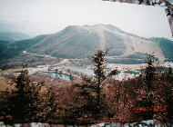
Mt Chaus 1415m
It is located in the prefecture border
of Nagano Prefecture and Aichi Prefecture.A
panorama opens the top of this mountain 360
times.A resort area spreads out in the circumference
in such cases as the auto-camping ground
・ stock farm ・ hot spring ・ golf course
of skiing ground ・ people vacation-mura
of Aichi Prefecture, Nagano Prefecture.
Cabin of the prefectural auto-camping ground
can stay comfortably with 1 person 2000 yen.
The hot spring of the village is near here
with the bath. It is the wonderful hot spring
which a Urugi village made.
As for the climbing a mountain course,
some mountain trails are prepared by the
side of the road which it goes through from
Chausuyam Lake to people vacation-mura of
Aichi Prefecture.
Mt Takamine
It goes from Aichi Prefecture into Nagano
Prefecture through Route 153, and goes into
Hiraya-mura through Neba-mura, and there
is a sign of the mountain trail in the neighborhood
of the village disconnection of Hiraya-mura,
the left of the national route.
It is the point of 6K to the top. it goes
to the top parking lot by car, and walks
from that to the observatory, one minute
One side is green around the top in the grazing
place.
If a climate is good, a young man is doing
a paraglider.
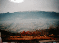
Mt Zyatouge 1664m
From Hiraya-mura, Route 153, to Namiai-mura
A Gibuzaka skiing ground is on the right
of the national route.
The side of the skiing ground is a cottage
area, and there is a road to go to the Zyatouge
summit of a mountain..
A road entrance is included in Naniai-mura
through Route 153 from Hiraya-mura.
There is a way from the right drive-in parking
lot of the Zibuzaka pass beginning.
It walks from the end where it passed a
cottage, the Umanose parking lot to the top,
and it is 30 minutes.
The Zyatouge summit of a mountain is the
long summit of a mountain like a snake summit
NTT radio station ・NHK commercial broadcasting
TV TV station ・ Ministry of Construction
radar rain gauge summit observatory 360 times
big panorama, too.
Mt Ooban 1695m
It is a mountain between Gifu Prefecture
Nakatsugawa and Nagano Prefecture Achi
village.
It leaves a central automatic roadway Achi
interchange, and faces Hebuns Sonohara skiing
ground direction.
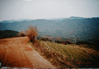
It goes to Misaka pass from the village
of Sonohara 【 the path through a forest
】
It parks in the Misaka pass, and goes to
Mt Ena from the mountain trail entrance of
the pass.
There is Mt Ooban in middle point one-hour
half place of Mt Ena s mountain trail.
It is the course which is good for the training.
It is when it walks from nearby Fujimidai (1739m), the Misaka pass (1569m) and the big panorama of 360 times
is all right for no less than 30 minutes.
Mt Ginbagata 1445m !It is wonderful.!
It is the mountain where it has the scale
of the nature that the both Alps of the central
Alps ・ south Alps which it can climb easily
can be looked over near here it feels greatly.
It goes to the Koshibu dam in the Ooshika
route from the central automatic roadway
Matukawa interchange.
It passes the tunnel of the Koshibu dam,
and goes for a while.
The sign of Mt Ginbagata direction can be
seen on the left of out of consideration
for the bridge.
It goes along the Shitoku River from there,
and the way which it climbs until the pass
lasts.
A roadway leads to the summit of a mountain
so that a ridge may go from the pass.
The Ginbagata summits of a mountain are a
stock farm and a camping ground.
A refuge hut is established in summertime,
too.
The west side puts the Tenryu River and Iigima-cho,
and meets it 【 the central Alps 】.
The east puts Ooshika-mura, and leads to
the south Alps.
Central Alps The south Alps
TOSHIO YAZAWA